pacman::p_load(sf, tidyverse)Hands-on Exercise 1: Geospatial Data Wrangling with R
Overview - 1
In this hands-on exercise, I learn how to import and wrangle geospatial data using appropriate R packages.
Getting Started
The code chunk below installs and loads sf and tidyverse packages into R environment.
Importing Geospatial Data
Importing polygon feature data in Shapefile format
mpsz <- st_read(dsn = "data/geospatial", layer = "MP14_SUBZONE_WEB_PL")Reading layer `MP14_SUBZONE_WEB_PL' from data source
`/Users/jonathanley/Dropbox/SMU Modules/ISSS624 - Applied Geospatial Analytics/Quarto/jonathanley1986/ISSS624/Hands-on_Ex/data/geospatial'
using driver `ESRI Shapefile'
Simple feature collection with 323 features and 15 fields
Geometry type: MULTIPOLYGON
Dimension: XY
Bounding box: xmin: 2667.538 ymin: 15748.72 xmax: 56396.44 ymax: 50256.33
Projected CRS: SVY21Importing Polyline feature data in Shapefile Format
cyclingpath <- st_read(dsn = "data/geospatial", layer = "CyclingPath")Reading layer `CyclingPath' from data source
`/Users/jonathanley/Dropbox/SMU Modules/ISSS624 - Applied Geospatial Analytics/Quarto/jonathanley1986/ISSS624/Hands-on_Ex/data/geospatial'
using driver `ESRI Shapefile'
Simple feature collection with 1625 features and 2 fields
Geometry type: LINESTRING
Dimension: XY
Bounding box: xmin: 12711.19 ymin: 28711.33 xmax: 42626.09 ymax: 48948.15
Projected CRS: SVY21Importing GIS feature data in KML format
preschool = st_read("data/geospatial/pre-schools-location-kml.kml")Reading layer `PRESCHOOLS_LOCATION' from data source
`/Users/jonathanley/Dropbox/SMU Modules/ISSS624 - Applied Geospatial Analytics/Quarto/jonathanley1986/ISSS624/Hands-on_Ex/data/geospatial/pre-schools-location-kml.kml'
using driver `KML'
Simple feature collection with 1359 features and 2 fields
Geometry type: POINT
Dimension: XYZ
Bounding box: xmin: 103.6824 ymin: 1.248403 xmax: 103.9897 ymax: 1.462134
z_range: zmin: 0 zmax: 0
Geodetic CRS: WGS 84Checking Content of Simple Feature Data Frame
Working with st_geometry()
st_geometry(mpsz)Geometry set for 323 features
Geometry type: MULTIPOLYGON
Dimension: XY
Bounding box: xmin: 2667.538 ymin: 15748.72 xmax: 56396.44 ymax: 50256.33
Projected CRS: SVY21
First 5 geometries:MULTIPOLYGON (((31495.56 30140.01, 31980.96 296...MULTIPOLYGON (((29092.28 30021.89, 29119.64 300...MULTIPOLYGON (((29932.33 29879.12, 29947.32 298...MULTIPOLYGON (((27131.28 30059.73, 27088.33 297...MULTIPOLYGON (((26451.03 30396.46, 26440.47 303...Working with glimpse()
glimpse(mpsz)Rows: 323
Columns: 16
$ OBJECTID <int> 1, 2, 3, 4, 5, 6, 7, 8, 9, 10, 11, 12, 13, 14, 15, 16, 17, …
$ SUBZONE_NO <int> 1, 1, 3, 8, 3, 7, 9, 2, 13, 7, 12, 6, 1, 5, 1, 1, 3, 2, 2, …
$ SUBZONE_N <chr> "MARINA SOUTH", "PEARL'S HILL", "BOAT QUAY", "HENDERSON HIL…
$ SUBZONE_C <chr> "MSSZ01", "OTSZ01", "SRSZ03", "BMSZ08", "BMSZ03", "BMSZ07",…
$ CA_IND <chr> "Y", "Y", "Y", "N", "N", "N", "N", "Y", "N", "N", "N", "N",…
$ PLN_AREA_N <chr> "MARINA SOUTH", "OUTRAM", "SINGAPORE RIVER", "BUKIT MERAH",…
$ PLN_AREA_C <chr> "MS", "OT", "SR", "BM", "BM", "BM", "BM", "SR", "QT", "QT",…
$ REGION_N <chr> "CENTRAL REGION", "CENTRAL REGION", "CENTRAL REGION", "CENT…
$ REGION_C <chr> "CR", "CR", "CR", "CR", "CR", "CR", "CR", "CR", "CR", "CR",…
$ INC_CRC <chr> "5ED7EB253F99252E", "8C7149B9EB32EEFC", "C35FEFF02B13E0E5",…
$ FMEL_UPD_D <date> 2014-12-05, 2014-12-05, 2014-12-05, 2014-12-05, 2014-12-05…
$ X_ADDR <dbl> 31595.84, 28679.06, 29654.96, 26782.83, 26201.96, 25358.82,…
$ Y_ADDR <dbl> 29220.19, 29782.05, 29974.66, 29933.77, 30005.70, 29991.38,…
$ SHAPE_Leng <dbl> 5267.381, 3506.107, 1740.926, 3313.625, 2825.594, 4428.913,…
$ SHAPE_Area <dbl> 1630379.27, 559816.25, 160807.50, 595428.89, 387429.44, 103…
$ geometry <MULTIPOLYGON [m]> MULTIPOLYGON (((31495.56 30..., MULTIPOLYGON (…Working with head()
head(mpsz, n=5)Simple feature collection with 5 features and 15 fields
Geometry type: MULTIPOLYGON
Dimension: XY
Bounding box: xmin: 25867.68 ymin: 28369.47 xmax: 32362.39 ymax: 30435.54
Projected CRS: SVY21
OBJECTID SUBZONE_NO SUBZONE_N SUBZONE_C CA_IND PLN_AREA_N
1 1 1 MARINA SOUTH MSSZ01 Y MARINA SOUTH
2 2 1 PEARL'S HILL OTSZ01 Y OUTRAM
3 3 3 BOAT QUAY SRSZ03 Y SINGAPORE RIVER
4 4 8 HENDERSON HILL BMSZ08 N BUKIT MERAH
5 5 3 REDHILL BMSZ03 N BUKIT MERAH
PLN_AREA_C REGION_N REGION_C INC_CRC FMEL_UPD_D X_ADDR
1 MS CENTRAL REGION CR 5ED7EB253F99252E 2014-12-05 31595.84
2 OT CENTRAL REGION CR 8C7149B9EB32EEFC 2014-12-05 28679.06
3 SR CENTRAL REGION CR C35FEFF02B13E0E5 2014-12-05 29654.96
4 BM CENTRAL REGION CR 3775D82C5DDBEFBD 2014-12-05 26782.83
5 BM CENTRAL REGION CR 85D9ABEF0A40678F 2014-12-05 26201.96
Y_ADDR SHAPE_Leng SHAPE_Area geometry
1 29220.19 5267.381 1630379.3 MULTIPOLYGON (((31495.56 30...
2 29782.05 3506.107 559816.2 MULTIPOLYGON (((29092.28 30...
3 29974.66 1740.926 160807.5 MULTIPOLYGON (((29932.33 29...
4 29933.77 3313.625 595428.9 MULTIPOLYGON (((27131.28 30...
5 30005.70 2825.594 387429.4 MULTIPOLYGON (((26451.03 30...Plotting Geospatial Data
Plotting in R Graphic
plot(mpsz)Warning: plotting the first 9 out of 15 attributes; use max.plot = 15 to plot
all
Plotting by Geometry
plot(st_geometry(mpsz))
Plotting by Specific Attribute
plot(mpsz["PLN_AREA_N"])
Working with Projection
Assigning EPSG code to a simple data frame
st_crs(mpsz)Coordinate Reference System:
User input: SVY21
wkt:
PROJCRS["SVY21",
BASEGEOGCRS["SVY21[WGS84]",
DATUM["World Geodetic System 1984",
ELLIPSOID["WGS 84",6378137,298.257223563,
LENGTHUNIT["metre",1]],
ID["EPSG",6326]],
PRIMEM["Greenwich",0,
ANGLEUNIT["Degree",0.0174532925199433]]],
CONVERSION["unnamed",
METHOD["Transverse Mercator",
ID["EPSG",9807]],
PARAMETER["Latitude of natural origin",1.36666666666667,
ANGLEUNIT["Degree",0.0174532925199433],
ID["EPSG",8801]],
PARAMETER["Longitude of natural origin",103.833333333333,
ANGLEUNIT["Degree",0.0174532925199433],
ID["EPSG",8802]],
PARAMETER["Scale factor at natural origin",1,
SCALEUNIT["unity",1],
ID["EPSG",8805]],
PARAMETER["False easting",28001.642,
LENGTHUNIT["metre",1],
ID["EPSG",8806]],
PARAMETER["False northing",38744.572,
LENGTHUNIT["metre",1],
ID["EPSG",8807]]],
CS[Cartesian,2],
AXIS["(E)",east,
ORDER[1],
LENGTHUNIT["metre",1,
ID["EPSG",9001]]],
AXIS["(N)",north,
ORDER[2],
LENGTHUNIT["metre",1,
ID["EPSG",9001]]]]mpsz3414 <- st_set_crs(mpsz, 3414) Warning: st_crs<- : replacing crs does not reproject data; use st_transform for
thatst_crs(mpsz3414)Coordinate Reference System:
User input: EPSG:3414
wkt:
PROJCRS["SVY21 / Singapore TM",
BASEGEOGCRS["SVY21",
DATUM["SVY21",
ELLIPSOID["WGS 84",6378137,298.257223563,
LENGTHUNIT["metre",1]]],
PRIMEM["Greenwich",0,
ANGLEUNIT["degree",0.0174532925199433]],
ID["EPSG",4757]],
CONVERSION["Singapore Transverse Mercator",
METHOD["Transverse Mercator",
ID["EPSG",9807]],
PARAMETER["Latitude of natural origin",1.36666666666667,
ANGLEUNIT["degree",0.0174532925199433],
ID["EPSG",8801]],
PARAMETER["Longitude of natural origin",103.833333333333,
ANGLEUNIT["degree",0.0174532925199433],
ID["EPSG",8802]],
PARAMETER["Scale factor at natural origin",1,
SCALEUNIT["unity",1],
ID["EPSG",8805]],
PARAMETER["False easting",28001.642,
LENGTHUNIT["metre",1],
ID["EPSG",8806]],
PARAMETER["False northing",38744.572,
LENGTHUNIT["metre",1],
ID["EPSG",8807]]],
CS[Cartesian,2],
AXIS["northing (N)",north,
ORDER[1],
LENGTHUNIT["metre",1]],
AXIS["easting (E)",east,
ORDER[2],
LENGTHUNIT["metre",1]],
USAGE[
SCOPE["Cadastre, engineering survey, topographic mapping."],
AREA["Singapore - onshore and offshore."],
BBOX[1.13,103.59,1.47,104.07]],
ID["EPSG",3414]]Transforming projection of preschool from wgs84 to svy21
preschool3414 <- st_transform (preschool, crs = 3414)

preschool3414
Simple feature collection with 1359 features and 2 fields
Geometry type: POINT
Dimension: XYZ
Bounding box: xmin: 11203.01 ymin: 25667.6 xmax: 45404.24 ymax: 49300.88
z_range: zmin: 0 zmax: 0
Projected CRS: SVY21 / Singapore TM
First 10 features:
Name
1 kml_1
2 kml_2
3 kml_3
4 kml_4
5 kml_5
6 kml_6
7 kml_7
8 kml_8
9 kml_9
10 kml_10
Description
1 <center><table><tr><th colspan='2' align='center'><em>Attributes</em></th></tr><tr bgcolor="#E3E3F3"> <th>CENTRE_NAME</th> <td>BIG FOOT PRE SCHOOL LLP</td> </tr><tr bgcolor=""> <th>CENTRE_CODE</th> <td>PT9281</td> </tr><tr bgcolor="#E3E3F3"> <th>ADDRESS</th> <td>196, WEST COAST ROAD, SINGAPORE 127375</td> </tr><tr bgcolor=""> <th>POSTAL_CODE</th> <td>127375</td> </tr><tr bgcolor="#E3E3F3"> <th>INC_CRC</th> <td>838CD358794FD031</td> </tr><tr bgcolor=""> <th>FMEL_UPD_D</th> <td>20171208174048</td> </tr></table></center>
2 <center><table><tr><th colspan='2' align='center'><em>Attributes</em></th></tr><tr bgcolor="#E3E3F3"> <th>CENTRE_NAME</th> <td>POSSO PRESCHOOL @ WEST COAST RISE PTE LTD</td> </tr><tr bgcolor=""> <th>CENTRE_CODE</th> <td>PT8684</td> </tr><tr bgcolor="#E3E3F3"> <th>ADDRESS</th> <td>30, WEST COAST RISE, HONG LEONG GARDEN, SINGAPORE 127473</td> </tr><tr bgcolor=""> <th>POSTAL_CODE</th> <td>127473</td> </tr><tr bgcolor="#E3E3F3"> <th>INC_CRC</th> <td>F331CEB175F9C254</td> </tr><tr bgcolor=""> <th>FMEL_UPD_D</th> <td>20171208174048</td> </tr></table></center>
3 <center><table><tr><th colspan='2' align='center'><em>Attributes</em></th></tr><tr bgcolor="#E3E3F3"> <th>CENTRE_NAME</th> <td>GENESIS CHILD CARE PTE. LTD.</td> </tr><tr bgcolor=""> <th>CENTRE_CODE</th> <td>PT9132</td> </tr><tr bgcolor="#E3E3F3"> <th>ADDRESS</th> <td>2A, JUBILEE ROAD, SINGAPORE 128524</td> </tr><tr bgcolor=""> <th>POSTAL_CODE</th> <td>128524</td> </tr><tr bgcolor="#E3E3F3"> <th>INC_CRC</th> <td>4C2E7E55019A633F</td> </tr><tr bgcolor=""> <th>FMEL_UPD_D</th> <td>20171208174048</td> </tr></table></center>
4 <center><table><tr><th colspan='2' align='center'><em>Attributes</em></th></tr><tr bgcolor="#E3E3F3"> <th>CENTRE_NAME</th> <td>LITTLE FOOTPRINTS PRESCHOOL PTE. LTD.</td> </tr><tr bgcolor=""> <th>CENTRE_CODE</th> <td>PT9260</td> </tr><tr bgcolor="#E3E3F3"> <th>ADDRESS</th> <td>6, JUBILEE ROAD, SINGAPORE 128531</td> </tr><tr bgcolor=""> <th>POSTAL_CODE</th> <td>128531</td> </tr><tr bgcolor="#E3E3F3"> <th>INC_CRC</th> <td>DDF98422A198387B</td> </tr><tr bgcolor=""> <th>FMEL_UPD_D</th> <td>20171208174048</td> </tr></table></center>
5 <center><table><tr><th colspan='2' align='center'><em>Attributes</em></th></tr><tr bgcolor="#E3E3F3"> <th>CENTRE_NAME</th> <td>AMAR KIDZ @ WEST COAST LLP</td> </tr><tr bgcolor=""> <th>CENTRE_CODE</th> <td>PT9016</td> </tr><tr bgcolor="#E3E3F3"> <th>ADDRESS</th> <td>8, JALAN LEMPENG, #02 - 03, PARK WEST CONDO, SINGAPORE 128796</td> </tr><tr bgcolor=""> <th>POSTAL_CODE</th> <td>128796</td> </tr><tr bgcolor="#E3E3F3"> <th>INC_CRC</th> <td>EAB3263D23F126AF</td> </tr><tr bgcolor=""> <th>FMEL_UPD_D</th> <td>20171208174048</td> </tr></table></center>
6 <center><table><tr><th colspan='2' align='center'><em>Attributes</em></th></tr><tr bgcolor="#E3E3F3"> <th>CENTRE_NAME</th> <td>TCC PRESCHOOL FABER PTE LTD</td> </tr><tr bgcolor=""> <th>CENTRE_CODE</th> <td>PT9299</td> </tr><tr bgcolor="#E3E3F3"> <th>ADDRESS</th> <td>60, FABER TERRACE, FABER HILLS, SINGAPORE 129040</td> </tr><tr bgcolor=""> <th>POSTAL_CODE</th> <td>129040</td> </tr><tr bgcolor="#E3E3F3"> <th>INC_CRC</th> <td>195E3739B77E6A5F</td> </tr><tr bgcolor=""> <th>FMEL_UPD_D</th> <td>20171208174048</td> </tr></table></center>
7 <center><table><tr><th colspan='2' align='center'><em>Attributes</em></th></tr><tr bgcolor="#E3E3F3"> <th>CENTRE_NAME</th> <td>ACEKIDZ @ COMMUNITY</td> </tr><tr bgcolor=""> <th>CENTRE_CODE</th> <td>PT5950</td> </tr><tr bgcolor="#E3E3F3"> <th>ADDRESS</th> <td>2, CLEMENTI WEST ST 2, #03 - 06, WEST COAST COMMUNITY CENTRE, SINGAPORE 129605</td> </tr><tr bgcolor=""> <th>POSTAL_CODE</th> <td>129605</td> </tr><tr bgcolor="#E3E3F3"> <th>INC_CRC</th> <td>9B1070EE1CB4A3E2</td> </tr><tr bgcolor=""> <th>FMEL_UPD_D</th> <td>20171208174048</td> </tr></table></center>
8 <center><table><tr><th colspan='2' align='center'><em>Attributes</em></th></tr><tr bgcolor="#E3E3F3"> <th>CENTRE_NAME</th> <td>PCF SPARKLETOTS PRESCHOOL @ QUEENSTOWN BLK 145 (CC)</td> </tr><tr bgcolor=""> <th>CENTRE_CODE</th> <td>ST0092</td> </tr><tr bgcolor="#E3E3F3"> <th>ADDRESS</th> <td>145, MEI LING STREET, #01 - 137, SINGAPORE 140145</td> </tr><tr bgcolor=""> <th>POSTAL_CODE</th> <td>140145</td> </tr><tr bgcolor="#E3E3F3"> <th>INC_CRC</th> <td>820E90716985CCCA</td> </tr><tr bgcolor=""> <th>FMEL_UPD_D</th> <td>20171208174048</td> </tr></table></center>
9 <center><table><tr><th colspan='2' align='center'><em>Attributes</em></th></tr><tr bgcolor="#E3E3F3"> <th>CENTRE_NAME</th> <td>PCF SPARKLETOTS PRESCHOOL @ QUEENSTOWN BLK 53A (CC)</td> </tr><tr bgcolor=""> <th>CENTRE_CODE</th> <td>ST0176</td> </tr><tr bgcolor="#E3E3F3"> <th>ADDRESS</th> <td>53A, STRATHMORE AVENUE, #01 - 01, FORFAR HEIGHTS, SINGAPORE 143053</td> </tr><tr bgcolor=""> <th>POSTAL_CODE</th> <td>143053</td> </tr><tr bgcolor="#E3E3F3"> <th>INC_CRC</th> <td>A7DC7D2C961A8822</td> </tr><tr bgcolor=""> <th>FMEL_UPD_D</th> <td>20171208174048</td> </tr></table></center>
10 <center><table><tr><th colspan='2' align='center'><em>Attributes</em></th></tr><tr bgcolor="#E3E3F3"> <th>CENTRE_NAME</th> <td>MY FIRST SKOOL</td> </tr><tr bgcolor=""> <th>CENTRE_CODE</th> <td>NT0510</td> </tr><tr bgcolor="#E3E3F3"> <th>ADDRESS</th> <td>106, HENDERSON CRESCENT, #01 - 37, SINGAPORE 150106</td> </tr><tr bgcolor=""> <th>POSTAL_CODE</th> <td>150106</td> </tr><tr bgcolor="#E3E3F3"> <th>INC_CRC</th> <td>EB3942B460BB5CBC</td> </tr><tr bgcolor=""> <th>FMEL_UPD_D</th> <td>20171208174048</td> </tr></table></center>
geometry
1 POINT Z (19997.26 32333.17 0)
2 POINT Z (19126.75 33114.35 0)
3 POINT Z (20345.12 31934.56 0)
4 POINT Z (20400.31 31952.36 0)
5 POINT Z (19810.78 33140.31 0)
6 POINT Z (19550.92 33770.18 0)
7 POINT Z (20378.07 31665.55 0)
8 POINT Z (24835.77 30689.38 0)
9 POINT Z (25139.3 30636.01 0)
10 POINT Z (26771.14 30203.71 0)Importing and Converting an Aspatial Data
Importing Aspatial Data
listings <- read_csv("data/aspatial/listings.csv")Rows: 4252 Columns: 16
── Column specification ────────────────────────────────────────────────────────
Delimiter: ","
chr (5): name, host_name, neighbourhood_group, neighbourhood, room_type
dbl (10): id, host_id, latitude, longitude, price, minimum_nights, number_o...
date (1): last_review
ℹ Use `spec()` to retrieve the full column specification for this data.
ℹ Specify the column types or set `show_col_types = FALSE` to quiet this message.list(listings)[[1]]
# A tibble: 4,252 × 16
id name host_id host_…¹ neigh…² neigh…³ latit…⁴ longi…⁵ room_…⁶ price
<dbl> <chr> <dbl> <chr> <chr> <chr> <dbl> <dbl> <chr> <dbl>
1 50646 Pleasan… 227796 Sujatha Centra… Bukit … 1.33 104. Privat… 80
2 71609 Ensuite… 367042 Belinda East R… Tampin… 1.35 104. Privat… 178
3 71896 B&B Ro… 367042 Belinda East R… Tampin… 1.35 104. Privat… 81
4 71903 Room 2-… 367042 Belinda East R… Tampin… 1.35 104. Privat… 81
5 275343 Conveni… 1439258 Joyce Centra… Bukit … 1.29 104. Privat… 52
6 275344 15 mins… 1439258 Joyce Centra… Bukit … 1.29 104. Privat… 40
7 294281 5 mins … 1521514 Elizab… Centra… Newton 1.31 104. Privat… 72
8 301247 Nice ro… 1552002 Rahul Centra… Geylang 1.32 104. Privat… 41
9 324945 20 Mins… 1439258 Joyce Centra… Bukit … 1.29 104. Privat… 49
10 330089 Accomo@… 1439258 Joyce Centra… Bukit … 1.29 104. Privat… 49
# … with 4,242 more rows, 6 more variables: minimum_nights <dbl>,
# number_of_reviews <dbl>, last_review <date>, reviews_per_month <dbl>,
# calculated_host_listings_count <dbl>, availability_365 <dbl>, and
# abbreviated variable names ¹host_name, ²neighbourhood_group,
# ³neighbourhood, ⁴latitude, ⁵longitude, ⁶room_typeCreating a simple feature data frame from aspatial data frame
listings_sf <- st_as_sf(listings, coords = c("longitude", "latitude"), crs=4326) %>%
  st_transform(crs = 3414)

glimpse(listings_sf)
Rows: 4,252
Columns: 15
$ id <dbl> 50646, 71609, 71896, 71903, 275343, 275…
$ name <chr> "Pleasant Room along Bukit Timah", "Ens…
$ host_id <dbl> 227796, 367042, 367042, 367042, 1439258…
$ host_name <chr> "Sujatha", "Belinda", "Belinda", "Belin…
$ neighbourhood_group <chr> "Central Region", "East Region", "East …
$ neighbourhood <chr> "Bukit Timah", "Tampines", "Tampines", …
$ room_type <chr> "Private room", "Private room", "Privat…
$ price <dbl> 80, 178, 81, 81, 52, 40, 72, 41, 49, 49…
$ minimum_nights <dbl> 90, 90, 90, 90, 14, 14, 90, 8, 14, 14, …
$ number_of_reviews <dbl> 18, 20, 24, 48, 20, 13, 133, 105, 14, 1…
$ last_review <date> 2014-07-08, 2019-12-28, 2014-12-10, 20…
$ reviews_per_month <dbl> 0.22, 0.28, 0.33, 0.67, 0.20, 0.16, 1.2…
$ calculated_host_listings_count <dbl> 1, 4, 4, 4, 50, 50, 7, 1, 50, 50, 50, 4…
$ availability_365 <dbl> 365, 365, 365, 365, 353, 364, 365, 90, …
$ geometry <POINT [m]> POINT (22646.02 35167.9), POINT (…Geoprocessing with sf package
Buffering
buffer_cycling <- st_buffer(cyclingpath, dist=5, nQuadSegs = 30)

buffer_cycling$AREA <- st_area(buffer_cycling)

sum(buffer_cycling$AREA)
773143.9 [m^2]Point in polygon count
mpsz3414$`PreSch Count`<- lengths(st_intersects(mpsz3414, preschool3414))

summary(mpsz3414$`PreSch Count`)
Min. 1st Qu. Median Mean 3rd Qu. Max.
0.000 0.000 2.000 4.207 6.000 37.000 top_n(mpsz3414, 1, `PreSch Count`)Simple feature collection with 1 feature and 16 fields
Geometry type: MULTIPOLYGON
Dimension: XY
Bounding box: xmin: 23449.05 ymin: 46001.23 xmax: 25594.22 ymax: 47996.47
Projected CRS: SVY21 / Singapore TM
OBJECTID SUBZONE_NO SUBZONE_N SUBZONE_C CA_IND PLN_AREA_N PLN_AREA_C
1 290 3 WOODLANDS EAST WDSZ03 N WOODLANDS WD
REGION_N REGION_C INC_CRC FMEL_UPD_D X_ADDR Y_ADDR
1 NORTH REGION NR C90769E43EE6B0F2 2014-12-05 24506.64 46991.63
SHAPE_Leng SHAPE_Area geometry PreSch Count
1 6603.608 2553464 MULTIPOLYGON (((24786.75 46... 37mpsz3414$Area <- mpsz3414 %>%
st_area()
mpsz3414 <- mpsz3414 %>%
mutate(`PreSch Density` = `PreSch Count`/Area * 1000000)Exploratory Data Analysis (EDA)
Plotting in Histogram
hist(mpsz3414$`PreSch Density`)
ggplot(data=mpsz3414,
       aes(x= as.numeric(`PreSch Density`)))+
  geom_histogram(bins=20,
                 color="black",
                 fill="light blue") +
  labs(title = "Are pre-school evenly distributed in Singapore?",
       subtitle= "There are many planning sub-zones with a single pre-school, on the other hand, \nthere are two planning sub-zones with at least 20 pre-schools",
      x = "Pre-school density (per km sq)",
      y = "Frequency")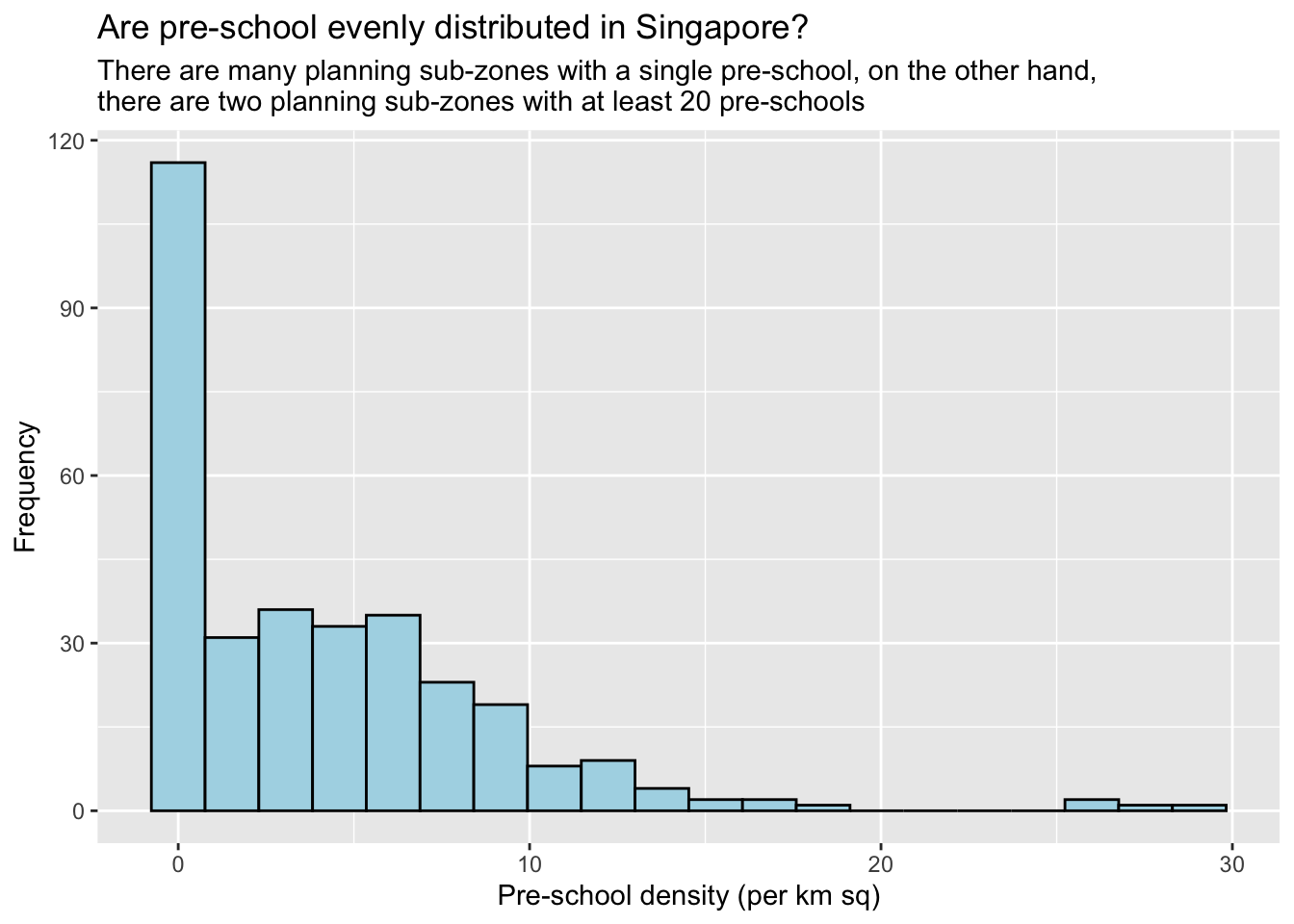
Plotting in Scatterplot
mpsz3414Simple feature collection with 323 features and 18 fields
Geometry type: MULTIPOLYGON
Dimension: XY
Bounding box: xmin: 2667.538 ymin: 15748.72 xmax: 56396.44 ymax: 50256.33
Projected CRS: SVY21 / Singapore TM
First 10 features:
OBJECTID SUBZONE_NO SUBZONE_N SUBZONE_C CA_IND PLN_AREA_N
1 1 1 MARINA SOUTH MSSZ01 Y MARINA SOUTH
2 2 1 PEARL'S HILL OTSZ01 Y OUTRAM
3 3 3 BOAT QUAY SRSZ03 Y SINGAPORE RIVER
4 4 8 HENDERSON HILL BMSZ08 N BUKIT MERAH
5 5 3 REDHILL BMSZ03 N BUKIT MERAH
6 6 7 ALEXANDRA HILL BMSZ07 N BUKIT MERAH
7 7 9 BUKIT HO SWEE BMSZ09 N BUKIT MERAH
8 8 2 CLARKE QUAY SRSZ02 Y SINGAPORE RIVER
9 9 13 PASIR PANJANG 1 QTSZ13 N QUEENSTOWN
10 10 7 QUEENSWAY QTSZ07 N QUEENSTOWN
PLN_AREA_C REGION_N REGION_C INC_CRC FMEL_UPD_D X_ADDR
1 MS CENTRAL REGION CR 5ED7EB253F99252E 2014-12-05 31595.84
2 OT CENTRAL REGION CR 8C7149B9EB32EEFC 2014-12-05 28679.06
3 SR CENTRAL REGION CR C35FEFF02B13E0E5 2014-12-05 29654.96
4 BM CENTRAL REGION CR 3775D82C5DDBEFBD 2014-12-05 26782.83
5 BM CENTRAL REGION CR 85D9ABEF0A40678F 2014-12-05 26201.96
6 BM CENTRAL REGION CR 9D286521EF5E3B59 2014-12-05 25358.82
7 BM CENTRAL REGION CR 7839A8577144EFE2 2014-12-05 27680.06
8 SR CENTRAL REGION CR 48661DC0FBA09F7A 2014-12-05 29253.21
9 QT CENTRAL REGION CR 1F721290C421BFAB 2014-12-05 22077.34
10 QT CENTRAL REGION CR 3580D2AFFBEE914C 2014-12-05 24168.31
Y_ADDR SHAPE_Leng SHAPE_Area geometry PreSch Count
1 29220.19 5267.381 1630379.3 MULTIPOLYGON (((31495.56 30... 0
2 29782.05 3506.107 559816.2 MULTIPOLYGON (((29092.28 30... 5
3 29974.66 1740.926 160807.5 MULTIPOLYGON (((29932.33 29... 0
4 29933.77 3313.625 595428.9 MULTIPOLYGON (((27131.28 30... 2
5 30005.70 2825.594 387429.4 MULTIPOLYGON (((26451.03 30... 1
6 29991.38 4428.913 1030378.8 MULTIPOLYGON (((25899.7 297... 10
7 30230.86 3275.312 551732.0 MULTIPOLYGON (((27746.95 30... 4
8 30222.86 2208.619 290184.7 MULTIPOLYGON (((29351.26 29... 4
9 29893.78 6571.323 1084792.3 MULTIPOLYGON (((20996.49 30... 3
10 30104.18 3454.239 631644.3 MULTIPOLYGON (((24472.11 29... 1
Area PreSch Density
1 1630379.3 [m^2] 0.000000 [1/m^2]
2 559816.2 [m^2] 8.931502 [1/m^2]
3 160807.5 [m^2] 0.000000 [1/m^2]
4 595428.9 [m^2] 3.358923 [1/m^2]
5 387429.4 [m^2] 2.581115 [1/m^2]
6 1030378.8 [m^2] 9.705169 [1/m^2]
7 551732.0 [m^2] 7.249896 [1/m^2]
8 290184.7 [m^2] 13.784327 [1/m^2]
9 1084792.3 [m^2] 2.765506 [1/m^2]
10 631644.3 [m^2] 1.583170 [1/m^2]ggplot(mpsz3414, aes(x = as.numeric('PreSch Density'), y = as.numeric('PreSch Count'))) +
geom_point(size=2) +
labs(title = "Is there a relationship between Pre-School Density and Pre-School Count?",
x = "Pre-school density (per km sq)",
y = "PreSch Count")Warning in FUN(X[[i]], ...): NAs introduced by coercion
Warning in FUN(X[[i]], ...): NAs introduced by coercion
Warning in FUN(X[[i]], ...): NAs introduced by coercion
Warning in FUN(X[[i]], ...): NAs introduced by coercionWarning: Removed 323 rows containing missing values (`geom_point()`).
Overview - 2
In this hands-on exercise, I learn how to conduct Choropleth Mapping using relevant packages.
Getting Started
The code chunk below will be used to install and load packages in RStudio.
pacman::p_load(sf, tmap, tidyverse)Importing Data into R
Importing Geospatial Data
mpsz <- st_read(dsn = "data/geospatial",
                layer = "MP14_SUBZONE_WEB_PL")
Reading layer `MP14_SUBZONE_WEB_PL' from data source
`/Users/jonathanley/Dropbox/SMU Modules/ISSS624 - Applied Geospatial Analytics/Quarto/jonathanley1986/ISSS624/Hands-on_Ex/data/geospatial'
using driver `ESRI Shapefile'
Simple feature collection with 323 features and 15 fields
Geometry type: MULTIPOLYGON
Dimension: XY
Bounding box: xmin: 2667.538 ymin: 15748.72 xmax: 56396.44 ymax: 50256.33
Projected CRS: SVY21mpszSimple feature collection with 323 features and 15 fields
Geometry type: MULTIPOLYGON
Dimension: XY
Bounding box: xmin: 2667.538 ymin: 15748.72 xmax: 56396.44 ymax: 50256.33
Projected CRS: SVY21
First 10 features:
OBJECTID SUBZONE_NO SUBZONE_N SUBZONE_C CA_IND PLN_AREA_N
1 1 1 MARINA SOUTH MSSZ01 Y MARINA SOUTH
2 2 1 PEARL'S HILL OTSZ01 Y OUTRAM
3 3 3 BOAT QUAY SRSZ03 Y SINGAPORE RIVER
4 4 8 HENDERSON HILL BMSZ08 N BUKIT MERAH
5 5 3 REDHILL BMSZ03 N BUKIT MERAH
6 6 7 ALEXANDRA HILL BMSZ07 N BUKIT MERAH
7 7 9 BUKIT HO SWEE BMSZ09 N BUKIT MERAH
8 8 2 CLARKE QUAY SRSZ02 Y SINGAPORE RIVER
9 9 13 PASIR PANJANG 1 QTSZ13 N QUEENSTOWN
10 10 7 QUEENSWAY QTSZ07 N QUEENSTOWN
PLN_AREA_C REGION_N REGION_C INC_CRC FMEL_UPD_D X_ADDR
1 MS CENTRAL REGION CR 5ED7EB253F99252E 2014-12-05 31595.84
2 OT CENTRAL REGION CR 8C7149B9EB32EEFC 2014-12-05 28679.06
3 SR CENTRAL REGION CR C35FEFF02B13E0E5 2014-12-05 29654.96
4 BM CENTRAL REGION CR 3775D82C5DDBEFBD 2014-12-05 26782.83
5 BM CENTRAL REGION CR 85D9ABEF0A40678F 2014-12-05 26201.96
6 BM CENTRAL REGION CR 9D286521EF5E3B59 2014-12-05 25358.82
7 BM CENTRAL REGION CR 7839A8577144EFE2 2014-12-05 27680.06
8 SR CENTRAL REGION CR 48661DC0FBA09F7A 2014-12-05 29253.21
9 QT CENTRAL REGION CR 1F721290C421BFAB 2014-12-05 22077.34
10 QT CENTRAL REGION CR 3580D2AFFBEE914C 2014-12-05 24168.31
Y_ADDR SHAPE_Leng SHAPE_Area geometry
1 29220.19 5267.381 1630379.3 MULTIPOLYGON (((31495.56 30...
2 29782.05 3506.107 559816.2 MULTIPOLYGON (((29092.28 30...
3 29974.66 1740.926 160807.5 MULTIPOLYGON (((29932.33 29...
4 29933.77 3313.625 595428.9 MULTIPOLYGON (((27131.28 30...
5 30005.70 2825.594 387429.4 MULTIPOLYGON (((26451.03 30...
6 29991.38 4428.913 1030378.8 MULTIPOLYGON (((25899.7 297...
7 30230.86 3275.312 551732.0 MULTIPOLYGON (((27746.95 30...
8 30222.86 2208.619 290184.7 MULTIPOLYGON (((29351.26 29...
9 29893.78 6571.323 1084792.3 MULTIPOLYGON (((20996.49 30...
10 30104.18 3454.239 631644.3 MULTIPOLYGON (((24472.11 29...Importing Attribute Data
popdata <- read_csv("data/aspatial/respopagesextod2011to2020.csv")Rows: 984656 Columns: 7
── Column specification ────────────────────────────────────────────────────────
Delimiter: ","
chr (5): PA, SZ, AG, Sex, TOD
dbl (2): Pop, Time
ℹ Use `spec()` to retrieve the full column specification for this data.
ℹ Specify the column types or set `show_col_types = FALSE` to quiet this message.Data Preparation
popdata2020 <- popdata %>%
  filter(Time == 2020) %>%
  group_by(PA, SZ, AG) %>%
  summarise(`POP` = sum(`Pop`)) %>%
  ungroup()%>%
  pivot_wider(names_from=AG,
              values_from=POP) %>%
  mutate(YOUNG = rowSums(.[3:6])
         +rowSums(.[12])) %>%
mutate(`ECONOMY ACTIVE` = rowSums(.[7:11])+
rowSums(.[13:15]))%>%
mutate(`AGED`=rowSums(.[16:21])) %>%
mutate(`TOTAL`=rowSums(.[3:21])) %>%
mutate(`DEPENDENCY` = (`YOUNG` + `AGED`)
/`ECONOMY ACTIVE`) %>%
  select(`PA`, `SZ`, `YOUNG`,
       `ECONOMY ACTIVE`, `AGED`,
       `TOTAL`, `DEPENDENCY`)
`summarise()` has grouped output by 'PA', 'SZ'. You can override using the
`.groups` argument.Joining Attribute Data with Geospatial Data
Convert values of PA and SZ fields to uppercase.
popdata2020 <- popdata2020 %>%
  mutate_at(.vars = vars(PA, SZ),
          .funs = funs(toupper)) %>%
  filter(`ECONOMY ACTIVE` > 0)
Warning: `funs()` was deprecated in dplyr 0.8.0.
ℹ Please use a list of either functions or lambdas:
# Simple named list: list(mean = mean, median = median)
# Auto named with `tibble::lst()`: tibble::lst(mean, median)
# Using lambdas list(~ mean(., trim = .2), ~ median(., na.rm = TRUE))Join geographical data and attribute data using planning subzone name
mpsz_pop2020 <- left_join(mpsz, popdata2020,
                          by = c("SUBZONE_N" = "SZ"))

write_rds(mpsz_pop2020, "data/rds/mpszpop2020.rds")
Choropleth Mapping of Geospatial Data using tmap
Plotting thematic map via qtm()
tmap_mode("plot")tmap mode set to plottingqtm(mpsz_pop2020,
fill = "DEPENDENCY")
Creating a choropleth map by using tmap’s elements
tm_shape(mpsz_pop2020)+
  tm_fill("DEPENDENCY",
          style = "quantile",
          palette = "Blues",
          title = "Dependency ratio") +
  tm_layout(main.title = "Distribution of Dependency Ratio by planning subzone",
            main.title.position = "center",
            main.title.size = 1.2,
            legend.height = 0.45,
            legend.width = 0.35,
            frame = TRUE) +
  tm_borders(alpha = 0.5) +
  tm_compass(type="8star", size = 2) +
  tm_scale_bar() +
  tm_grid(alpha =0.2) +
  tm_credits("Source: Planning Sub-zone boundary from Urban Redevelopment Authorithy (URA)\n and Population data from Department of Statistics DOS",
             position = c("left", "bottom"))
Drawing a base map
tm_shape(mpsz_pop2020) +
  tm_polygons()
Drawing a choropleth map using tm_polygons()
tm_shape(mpsz_pop2020)+
  tm_polygons("DEPENDENCY")
Drawing a choropleth map using tm_fill() and tm_border()
tm_shape(mpsz_pop2020)+
  tm_fill("DEPENDENCY")
tm_shape(mpsz_pop2020)+
  tm_fill("DEPENDENCY") +
  tm_borders(lwd = 0.1,  alpha = 1)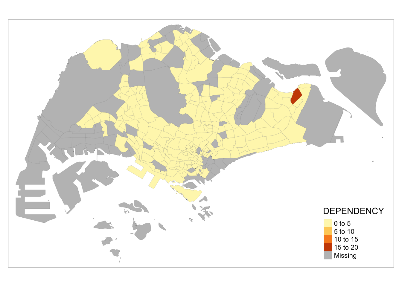
Plotting choropleth maps with built-in classification methods
tm_shape(mpsz_pop2020)+
  tm_fill("DEPENDENCY",
          n = 5,
          style = "jenks") +
  tm_borders(alpha = 0.5)
tm_shape(mpsz_pop2020)+
  tm_fill("DEPENDENCY",
          n = 5,
          style = "equal") +
  tm_borders(alpha = 0.5)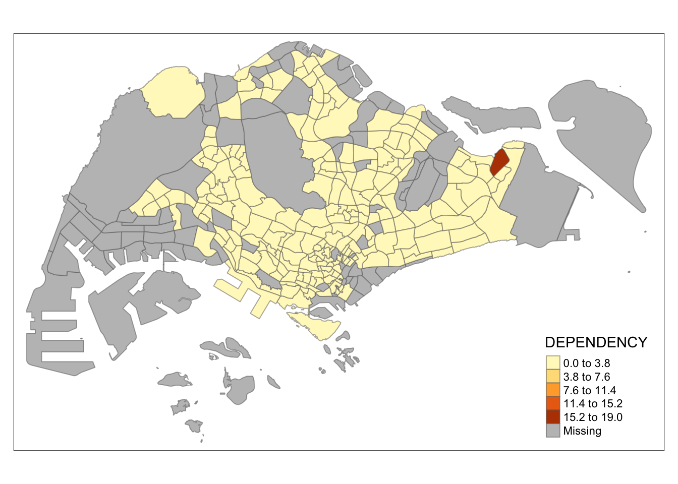
Plotting choropleth maps with custome break
summary(mpsz_pop2020$DEPENDENCY) Min. 1st Qu. Median Mean 3rd Qu. Max. NA's
0.0000 0.6519 0.7025 0.7742 0.7645 19.0000 92 Using ColourBrewer palette
tm_shape(mpsz_pop2020)+
  tm_fill("DEPENDENCY",
          n = 6,
          style = "quantile",
          palette = "Blues") +
  tm_borders(alpha = 0.5)
tm_shape(mpsz_pop2020)+
  tm_fill("DEPENDENCY",
          style = "quantile",
          palette = "-Greens") +
  tm_borders(alpha = 0.5)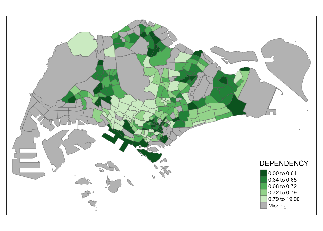
Map Layouts - Legend
tm_shape(mpsz_pop2020)+
  tm_fill("DEPENDENCY",
          style = "jenks",
          palette = "Blues",
          legend.hist = TRUE,
          legend.is.portrait = TRUE,
          legend.hist.z = 0.1) +
  tm_layout(main.title = "Distribution of Dependency Ratio by planning subzone \n(Jenks classification)",
            main.title.position = "center",
            main.title.size = 1,
            legend.height = 0.45,
            legend.width = 0.35,
            legend.outside = FALSE,
            legend.position = c("right", "bottom"),
            frame = FALSE) +
  tm_borders(alpha = 0.5)
Map Style
tm_shape(mpsz_pop2020)+
  tm_fill("DEPENDENCY",
          style = "quantile",
          palette = "-Greens") +
  tm_borders(alpha = 0.5) +
  tmap_style("classic")
tmap style set to "classic"other available styles are: "white", "gray", "natural", "cobalt", "col_blind", "albatross", "beaver", "bw", "watercolor" 
Cartographic Furniture
tm_shape(mpsz_pop2020)+
  tm_fill("DEPENDENCY",
          style = "quantile",
          palette = "Blues",
          title = "No. of persons") +
  tm_layout(main.title = "Distribution of Dependency Ratio \nby planning subzone",
            main.title.position = "center",
            main.title.size = 1.2,
            legend.height = 0.45,
            legend.width = 0.35,
            frame = TRUE) +
  tm_borders(alpha = 0.5) +
  tm_compass(type="8star", size = 2) +
  tm_scale_bar(width = 0.15) +
  tm_grid(lwd = 0.1, alpha = 0.2) +
  tm_credits("Source: Planning Sub-zone boundary from Urban Redevelopment Authorithy (URA)\n and Population data from Department of Statistics DOS",
             position = c("left", "bottom"))
tmap_style("white")tmap style set to "white"other available styles are: "gray", "natural", "cobalt", "col_blind", "albatross", "beaver", "bw", "classic", "watercolor" Drawing Small Multiple Choropleth Maps
Assigning multiple values to at least 1 aesthetic arguments
tm_shape(mpsz_pop2020)+
  tm_fill(c("YOUNG", "AGED"),
          style = "equal",
          palette = "Blues") +
  tm_layout(legend.position = c("right", "bottom")) +
  tm_borders(alpha = 0.5) +
  tmap_style("white")
tmap style set to "white"other available styles are: "gray", "natural", "cobalt", "col_blind", "albatross", "beaver", "bw", "classic", "watercolor" 
tm_shape(mpsz_pop2020)+
  tm_polygons(c("DEPENDENCY","AGED"),
          style = c("equal", "quantile"),
          palette = list("Blues","Greens")) +
  tm_layout(legend.position = c("right", "bottom"))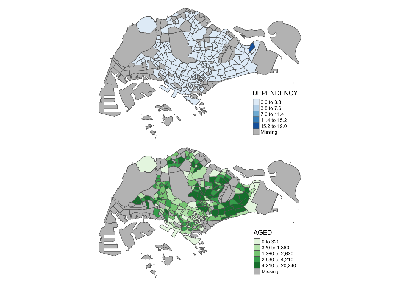
Defining a group-by variable in tm_facets()
tm_shape(mpsz_pop2020) +
  tm_fill("DEPENDENCY",
          style = "quantile",
          palette = "Blues",
          thres.poly = 0) +
  tm_facets(by="REGION_N",
            free.coords=TRUE,
            drop.shapes=TRUE) +
  tm_layout(legend.show = FALSE,
            title.position = c("center", "center"),
            title.size = 20) +
  tm_borders(alpha = 0.5)
Warning: The argument drop.shapes has been renamed to drop.units, and is
therefore deprecated
Creating multiple standalone maps with tmap_arrange()
youngmap <- tm_shape(mpsz_pop2020)+
  tm_polygons("YOUNG",
              style = "quantile",
              palette = "Blues")

agedmap <- tm_shape(mpsz_pop2020)+
  tm_polygons("AGED",
              style = "quantile",
              palette = "Blues")

tmap_arrange(youngmap, agedmap, asp=1, ncol=2)
Mapping spatial object meeting a selection criterion
tm_shape(mpsz_pop2020[mpsz_pop2020$REGION_N=="CENTRAL REGION", ])+
  tm_fill("DEPENDENCY",
          style = "quantile",
          palette = "Blues",
          legend.hist = TRUE,
          legend.is.portrait = TRUE,
          legend.hist.z = 0.1) +
  tm_layout(legend.outside = TRUE,
            legend.height = 0.45,
            legend.width = 5.0,
            legend.position = c("right", "bottom"),
            frame = FALSE) +
  tm_borders(alpha = 0.5)
Warning in pre_process_gt(x, interactive = interactive, orig_crs =
gm$shape.orig_crs): legend.width controls the width of the legend within a map.
Please use legend.outside.size to control the width of the outside legend